Invention content
In order to overcome the shortcomings and deficiencies of the prior art, the present invention discloses a parking space map generation method, apparatus, equipment and storage medium, which can improve the drawing accuracy of the parking space map, ensure the drawing speed of the map, the method comprises:
Determine the image of the parking space to be processed from the garage point cloud depth image; The parking space image to be processed includes at least one target parking space image;
determine at least three image vertices in the image of the parking space to be processed; At least three image vertices connected sequentially to form a path sequence clockwise; the first image vertex and the second image vertex in at least three image vertices, located on the same parking space exit line in the image of the parking space to be processed; the second image vertex and the third image vertex are located on the same parking space side edge in the parking space image to be processed; The first image vertex is the starting vertex of at least three image vertices;
Based on the position information of at least three image vertices in the parking space image to be processed, the parking space area to be drawn with parking space direction information is generated;
Based on the parking space layout configuration information, the parking space is drawn in the area of the parking space to be drawn to generate a parking space map; The parking space layout configuration information is determined based on the image of the parking space to be processed.
Further, the parking space map comprises at least one target parking space corresponding to the target parking space identification;
Based on the parking space layout configuration information, the parking space is drawn in the area of the parking space to be drawn to generate a parking space map, comprising:
Based on the parking space layout configuration information, draw at least one target parking space area in the parking area to be drawn;
The target parking space identification is added to at least one of the target parking space areas to obtain a parking space map corresponding to the image of the parking space to be processed.
Further, the target parking space identification is added to at least one of the target parking space areas, and a parking space map corresponding to the image of the parking space to be processed is obtained, comprising:
Determine the location information and direction information of the target parking space identification in each target parking area; The direction information makes the logo displayed positively at the target angle; The target angle is the angle at which the exit line of any target parking area is pointed to any target parking area;
The target parking space identification is added based on the location information and the direction information, and the parking space map corresponding to the parking space image to be processed is obtained.
Further, the location information that determines the target parking space identification in each target parking area comprising:
Based on the two side lines of each target parking area, the target median line of each target parking area is determined, and the target median line is parallel to the two side lines;
Based on the target median line corresponding to each target parking area and the same parking space exit line, the location information of each target parking space identification is determined, the center point of the target parking space identification is located on the target median line, and the distance between the target parking space identification and the same parking space exit line is a preset length.
Further, the method further comprises:
In the case that the number of rows of the target parking space in the image of the parking space to be processed is two lines, the area line opposite the exit line of the same parking space in the area of the parking space to be drawn is determined to be the relative parking space exit line;
The target parking space identification is added to at least one of the target parking space areas, and a parking space map corresponding to the image of the parking space to be processed is obtained, comprising:
Based on the same parking space exit line and the relative parking space exit line, determine the target parking space exit line corresponding to each target parking space area;
Based on the exit line of the target parking space, the location information and direction information of each target parking space are determined respectively; The direction information makes the target parking space identification displayed positively at the target angle; The target angle is the angle at which the exit line of any target parking area is pointed to any target parking area;
Based on the location information and the direction information, the target parking space identification is added to the target parking area, and the parking space map corresponding to the parking space image to be processed is obtained.
Further, the method further comprises:
In the case that the number of rows of the target parking space in the image of the parking space to be processed is greater than two lines, the parking space line parallel to the same parking space exit line and the shortest distance in each target parking space area is determined to be a parallel parking space exit line;
The target parking space identification is added to at least one of the target parking space areas, and a parking space map corresponding to the image of the parking space to be processed is obtained, comprising:
Based on the corresponding parallel parking space exit line of each target parking area, determine the location information and direction information of each target parking area; The direction information makes the target parking space identification displayed positively at the target angle; The target angle is the angle at which the same parking space exit line points to the area of any target parking space;
The target parking space identification is added based on the location information and the direction information of the target parking area, and the parking space map corresponding to the parking space image to be processed is obtained.
Further, after determining the parking space image to be processed from the garage point cloud depth image, the method further comprises:
In the case that the parking space image to be processed is non-quadrilateral, the image of the parking space to be processed is divided into a plurality of target areas, and the plurality of target areas are quadrilaterals;
The determining at least three image vertices in the image of the parking space to be processed, further comprising:
Identify at least three image vertices in each target region separately.
On the other hand, the present application also provides a parking space map generation device, comprising:
The first determination module is used to determine the image of the parking space to be processed from the garage point cloud depth image; The parking space image to be processed includes at least one target parking space image;
a second determination module for determining at least three image vertices in the image of the parking space to be processed; At least three image vertices connected sequentially to form a path sequence clockwise; the first image vertex and the second image vertex in at least three image vertices, located on the same parking space exit line in the image of the parking space to be processed; the second image vertex and the third image vertex are located on the same parking space side edge in the parking space image to be processed; The first image vertex is the starting vertex of at least three image vertices;
a generation module for generating the parking space area to be drawn with parking direction information based on the position information of at least three image vertices in the parking space image to be processed;
Drawing module, for drawing parking spaces in the area of the parking space to be drawn based on the parking space layout configuration information, and generating a parking space map; The parking space layout configuration information is determined based on the image of the parking space to be processed.
Thirdly, the present application also provides an electronic device, wherein the device comprises a processor and a memory, the memory stores at least one instruction, at least one piece of program, code set or instruction set, at least one instruction, at least one paragraph of program, the code set or instruction set is loaded and executed by the processor to achieve a parking space map generation method described above.
In a fourth aspect, the present application also provides a computer-readable storage medium, the storage medium is stored with at least one instruction, at least one program, code set or instruction set, at least one instruction, at least one program, code set or instruction set is loaded by the processor and performs a parking space map generation method described above.
Implementation of the present invention, has the following beneficial effects:
The present application determines clockwise the three image vertices of the parking space image to be processed, generates the parking space area to be drawn with parking space direction information according to the parallel line theorem, can ensure the drawing accuracy of the parking space area to be drawn, the three image vertices are artificially determined, the accuracy is higher, based on the parking space layout configuration information in the parking space area to be drawn, the parking space is drawn in batch, the map drawing efficiency is improved, and the same parking space exit line of the parking space image to be processed can be accurately determined based on the first image vertex and the second image vertex, In addition, the position information and direction information of the subsequent parking space identification number can be determined to improve the accuracy of parking space drawing.
Specific embodiment
In order to enable persons in the art to better understand the technical solution in the present application, the following will be combined with the accompanying drawings in the present application embodiment, the technical solution in the present application embodiment is clearly and completely described, obviously, the described embodiment is only a part of the present application embodiment, not all embodiments. Based on the embodiments in the present application, all other embodiments obtained by those of ordinary skill in the art without performing creative labor shall fall within the scope of protection of the present application.
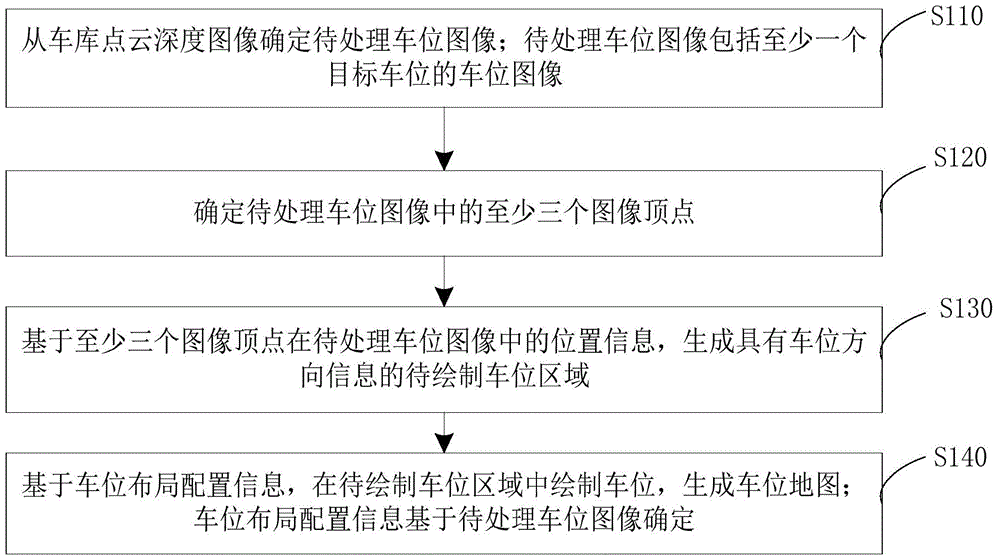
In the present embodiment, the technical problem to be solved by the present invention is to be able to improve the drawing accuracy of the parking space map, while ensuring the drawing speed of the map. Referring to Figure 1, the method comprises:
S110: Determine the image of the parking space to be processed from the garage point cloud depth image; The image of the parking space to be processed includes an image of the parking space of at least one target parking space;
The main body of the present embodiment is a server or user terminal, the point cloud data collected by lidar is processed into the warehouse, the garage point cloud depth image is obtained, the garage point cloud depth image is loaded through the 3D drawing protocol, and the basic tool page is built based on JavaScript (interpreted scripting language) and react (web development framework), which can support the user to configure the number of rows and columns of the parking space, and can draw a map with reference to the garage point cloud depth image, and a parking space includes multiple images to be processed, Each image to be processed includes at least one parking space of the target parking space image, according to the current existing road scene, the target car distribution in each space image to be processed is divided into 1 row 1 column, 2 rows 2 columns, 1 row n column, 1 column n row, 2 rows n rows, 2 rows n rows and other scenes, wherein n>2, the target parking space includes a conventional rectangular parking space and an inclined parallelogram parking space.
S120: Determine at least three image vertices in the image of the parking space to be processed; At least three image vertices are connected sequentially to form a clockwise path order; The first image vertex and the second image vertex of at least three image vertices, located on the same parking space exit line in the parking space image to be processed; The second image vertex and the third image vertex are located on the same parking space side edge in the parking space image to be processed; The first image vertex is the starting vertex of at least three image vertices;
In general, the image of the parking space to be processed is a quadrilateral, determine at least three image vertices of the quadrangle, in order to improve the drawing accuracy of the map, the garage point cloud depth image is displayed on the map drawing interface, the parking space image to be processed is determined according to the displayed garage point cloud depth image, at least three image vertices are determined at the image edge of the parking space image to be processed, the three image vertices are three consecutive vertices of the quadrilateral clockwise, and the connection line between the first image vertex and the second image vertex is the same parking space exit line in the parking space image to be processed. The parking space exit line is the area line adjacent to the road of the parking space image to be processed, the vehicle enters and exits the parking space, the same parking space exit line that first passes, in order to improve the accuracy of parking space mapping, the image vertex can be increased, in addition to the four image vertices in the parking space image to be processed, the edge point of the parking space image to be processed can also be determined.
S130: Based on the position information of at least three image vertices in the parking space image to be processed, the parking space area to be drawn with parking direction information is generated;
At least three image vertices are connected to form the same parking space exit line and the same parking space side edge line, based on the parallel line theorem, the parking space area to be drawn with parking space direction information is obtained, that is, the quadrilateral boundary line of the parking space image to be processed, based on the same exit opening line and the same parking space side edge line defense line, can determine the parking space direction information, parking space direction information is the direction pointing to the parking space exit line, based on the parking space direction information can determine the relevant numbers in the map, such as parking space identification numbers, road guidance lines.
S140: Based on the parking space layout configuration information, draw the parking space in the area to be drawn and generate a parking space map; The parking space layout configuration information is determined based on the image of the parking space to be processed.
Enter parking space layout configuration information, parking space layout configuration information includes the number of rows and columns of the target parking space in the image of the parking space to be processed, evenly split out each target parking space, draw each target parking space in the parking space area to be drawn, generate parking space map, parking space map has parking direction information, can be based on parking space direction information in the parking space map to draw relevant labels, such as parking space identification, road guide line, the current automatic recognition algorithm because of data quality, algorithm recognition accuracy and other problems are difficult to accurately identify the vertex of the target parking space , can not accurately identify the same parking space exit line, and the completed parking space map does not match the actual garage scene and other problems, can not avoid manual participation, the present embodication generates the parking space area to be drawn with parking space direction information, can ensure the drawing accuracy of the parking space area to be drawn, based on the parking space layout configuration information in the parking space area to be drawn to draw parking spaces, to achieve batch mapping and improve map drawing efficiency, Based on the vertex of the first image and the vertex of the second image, the same parking space exit line of the parking space image to be processed can be accurately determined, and then the position information and direction information of the subsequent parking space identification number can be determined, and the parking space drawing accuracy can be improved.
In an embodiment, the parking space map includes at least one target parking space corresponding to the target parking space identification;
Based on the parking space layout configuration information, draw parking spaces in the area of parking spaces to be drawn and generate parking space maps, including:
Based on the parking space layout configuration information, draw at least one target parking space area in the parking area to be drawn;
Add target parking space identification in at least one target parking area to obtain a parking space map corresponding to the image of the parking space to be processed.
Each target parking space is drawn with the corresponding target parking space identification, the target parking space identification is the parking space number, in general, the perspective of querying the target parking space identification is to stand in the direction of the target parking space exit line to look at the target parking space area, so the parking space identification is added close to the exit line of the target parking area, so that the user can clearly observe the target parking space identification; It can facilitate users to find the target parking space and improve the convenience of users.
In one embodiment, the target parking space identification is added to at least one target parking area to obtain a parking space map corresponding to the image of the parking space to be processed, comprising:
Determine the location information and direction information of the target parking space identification in each target parking area; The orientation information makes the logo display positively at the target angle; The target angle is the angle at which the exit line of any target parking area points to any target parking area;
According to the order of processing of each parking space image to be processed, the content of the target parking space identification in the target parking area is determined in turn, and the content of the target parking space identification can be taken as the starting point of the target parking space area where the first image vertex is located, and the content of the target parking space identification in the target parking area where the first image vertex of the first parking space image to be processed is "001", and the content of the target parking space identification to the last target parking space area is marked in a clockwise direction “005”; In the target parking space identification of the first target parking space area in the second parking space image to be treated, the corresponding label is "006", and the content of the target parking space identification in each target parking area in the second target parking space image is determined in turn, so that the content of each target parking space identification is not repeated in the garage.
Based on location information and direction information, the target parking space identification is added to obtain the parking space map corresponding to the parking space image to be processed.
Referring to the parking space map of 1 row n columns shown in Figure 2, based on the first image vertex, the second image vertex and the third image vertex to determine the parking space area to be drawn with parking space direction information, the connection between the first image vertex and the second image vertex is the same parking space exit line, correspondingly, the parking space line of each target parking space located in the same parking space exit line is the exit line of the target parking space, the user stands in the direction of the same parking space exit line, when looking at any target parking space area, the target parking space identification is displayed as positive. Add the target parking space identification in the target parking space area, under normal circumstances, the user station query the target parking space identification in the direction of the exit line, so the location of the parking space identification added is close to the exit line of the target parking space, so that the user can clearly observe the target parking space identification; The direction of the target parking space identification is that the user stands at the exit line of the target parking space when looking at the target parking space identification, the target parking space is positive, which can facilitate the user to find the target parking space, the above is the actual garage parking space identification drawing method, in the parking space map, the target parking space identification and the actual parking space in the parking space identification position and direction should be consistent, to ensure the consistency of the parking space map and the actual parking space.
In one embodiment, determining the location information of the target parking space identification in each target parking area, comprising:
Based on the two side lines of each target parking area, the target median line of each target parking area is determined, and the target median line is parallel to the two side lines.
Based on the target median line corresponding to each target parking area and the exit line of the same parking space, the location information of each target parking space identification is determined, the center point of the target parking space identification is located on the target median position, and the distance between the target parking space identification and the same parking space exit line is a preset length.
Referring to Figure 2, the target parking space identification is generally set in the center of the target parking area, based on the two side lines of the target parking space area, determine the target median line, the target median line is equal to the distance between the two side lines, the center point of the target parking space identification is located on the target median line, the target parking space logo is parallel to the same parking space exit line, the distance between the target parking space logo and the same parking space exit line is a preset length, the preset length can be zero, that is, the target parking space logo is located on the exit line of the target parking space, enter the parking space layout configuration information, Then through the first image vertex, the second image vertex and the third image vertex, the parking space map corresponding to the parking space area to be drawn can be generated in batches, and the parking space map contains the target parking space identification corresponding to each target parking space area, and the location information and direction information of the target parking space identification are determined through the first image vertex, the second image vertex and the third image vertex, so as to improve the drawing accuracy of the parking space map and improve the efficiency of drawing the map.
In one embodiment, the method further comprises:
When the number of rows of the target parking space in the image of the parking space to be processed is two lines, the area line opposite to the exit line of the same parking space in the parking space area to be drawn is determined as the relative parking space exit line;
Referring to the 2-row n train space map shown in Figure 3, n>2, the connection line between the first image vertex and the second image vertex in the figure is the same parking space exit line, and the area line opposite the same parking space exit line is determined as the relative parking space exit line, each target parking area has a corresponding exit line, the exit line of the target parking area located in the lower row is located on the same parking space exit line, and the exit line of the target parking area located in the upper row is located on the opposite parking space exit line (shown by the dotted line in the figure).
Add target parking space identification to at least one target parking area to obtain a parking space map corresponding to the image of the parking space to be processed, including:
Based on the same parking space exit line and the opposite parking space exit line, determine the target parking space exit line corresponding to each target parking space area;
Based on the exit line of the target parking space, determine the location information and direction information of each target parking space respectively; The direction information makes the target parking space sign display positively at the target angle; The target angle is the angle at which the exit line of any target parking area points to any target parking area;
Based on the target parking space exit line corresponding to each target parking space area, determine the location information and direction information of the target parking space identification, and the location information is determined in a way that: the two side lines of the target parking space area determine the target median line, the center point of the target parking space identification is located on the target median line, the target parking space line is parallel to the same parking space exit line, the distance between the target parking space logo and the target parking space exit line is a preset length, the preset length can be zero, and the target parking space identification is located on the exit line of the target parking space; The direction information makes the target parking space sign display positively at the target angle; The target angle is the angle at which the exit line of the target parking space corresponding to any target parking area points to any target parking area; The content of the target parking space identification can be based on the target parking area where the first image vertex is located, and the number is marked in a clockwise direction, that is, as shown in Figure 3, the content of the target parking space identification of the target parking space area where the first image vertex is located is "001", and it is numbered in a clockwise direction, to the content of the target parking space identification of the last target parking area traveling with "001" is "005", and "006" above "005", The content of the target parking space identification to the last target parking area in the parking space map is "010".
Based on the location information and direction information, the target parking space identification is added to the target parking space area, and the parking space map corresponding to the parking space image to be processed is obtained.
Add the target parking space identification to the target parking space area with location information and direction information, and when there are two rows in the target parking space area, the target parking space identification with opposite directions can be automatically generated with reference to the actual parking space situation, and the parking space map corresponding to the parking space image to be processed is obtained, which improves the drawing accuracy of the parking space map and improves the efficiency of drawing the map.
In one embodiment, the method further comprises:
When the number of rows of the target parking space in the image of the parking space to be processed is greater than two lines, the parking space line parallel to the same parking space exit line and the shortest distance in each target parking space area is determined as the parallel parking space exit line;
Referring to the 2-column n-row parking space map shown in Figure 4, Figure 4 is the side orientation situation, which can also be applied to the 1-column n-row parking space map, wherein n>2, the parking space line parallel to the same parking space exit line and the shortest distance in each target parking space area is determined as the parallel parking space exit line, that is, the exit line of each target parking space area.
Add target parking space identification to at least one target parking area to obtain a parking space map corresponding to the image of the parking space to be processed, including:
Based on the corresponding parallel parking space exit line of each target parking area, determine the location information and direction information of each target parking area; The direction information makes the target parking space sign display positively at the target angle; The target angle is the angle at which the same parking space exit line points to any target parking space area; The determination method of location information: the two side lines of the target parking space area determine the target median line, the center point of the target parking space identification is located on the target median line, the target parking space identification is parallel to the same parking space exit line, the distance between the target parking space identification and the same parking space exit line is the preset length, the preset length can be zero, and the target parking space identification is located on the exit line of the target parking space area; The direction information makes the target parking space sign display positively at the target angle; The target angle is the angle at which the same parking space exit line points to any target parking space area; In the case of the parking space as the side orientation, the content of the target parking space identification can be based on the target parking area where the first image vertex is located, and the number is marked in turn with the counterclockwise direction, as shown in Figure 4, the content of the target parking space identification of the target parking space area where the first image vertex is located is "001", and it is numbered in reverse clockwise direction, to the content of the target parking space identification of the last target parking area in the same column as "001" is "003", and "004" in the counterclockwise direction of "003", The target parking space ID to the last target parking area in the parking space map is "006".
Based on the location information and direction information, the target parking space identification is added to obtain the parking space map corresponding to the parking space image to be processed.
The location information and direction information add the target parking space identification to the target parking space area, and when there are multiple columns in the target parking space area, all the target parking space signs with the same direction can be automatically generated to obtain the parking space map corresponding to the parking space image to be processed, which improves the drawing accuracy of the parking space map and improves the efficiency of drawing the map.
In a special case, the target parking area in the parking space map is 2 rows and 2 columns, it is necessary to determine whether the direction information of the target parking space identification of the two rows is the same direction or reverse, if the direction information of the target parking space identification of the 2 rows is the same direction, as shown in Figure 5, the parking space map of 2 rows and 2 columns is processed in the way of 2 columns n rows, or 1 column n rows, that is, in each target parking area, the parking space line parallel to the same parking space exit line and the shortest distance is determined as the exit line of the target parking area. Then determine the location information and direction information of the target parking space mark; If the direction information of the target parking space identification of 2 rows is codirectional, as shown in Figure 6, the parking space map of 2 rows and 2 columns is processed according to the method of 2 rows and N columns, that is, the area line opposite to the exit line of the same parking space in the parking space area to be drawn is determined as the relative parking space exit line, and the target parking space exit line of each target parking space area is determined, and then the location information and direction information of the target parking space identification are determined.
In one embodiment, after determining the parking space image to be processed from the garage point cloud depth image, the method further comprises:
In the case that the image of the parking space to be processed is non-quadrilateral, the image of the parking space to be processed is divided into multiple target areas, and multiple target areas are quadrilaterals;
Identify at least three image vertices in the image of the parking space to be processed, including:
Identify at least three image vertices in each target region separately.
In the case that the image of the parking space to be processed is non-quadrilateral, that is, in the parking space image to be processed, the number of target parking areas in each row and/or column is different, or the target parking area of each row and/or column is misaligned, such as the parking space image to be processed includes two rows and two columns of target parking areas, and there are a total of three target parking spaces, the parking space image to be processed is divided into multiple target areas, multiple target areas are quadrilateral, and each target area forms a parking space image to be processed. Determine at least three image vertices on each target area, and draw the parking space map corresponding to the target area based on at least three image vertices to realize diversified drawing of parking space maps.
The present implementation also provides a parking space map generation device, the device is capable of implementing all of the above method steps, as shown in FIG. 7, the device comprising:
First determination module 710 for determining the image of the parking space to be processed from the garage point cloud depth image; The image of the parking space to be processed includes an image of the parking space of at least one target parking space;
a second determination module 720 for determining at least three image vertices in the image of the parking space to be processed; At least three image vertices are connected sequentially to form a clockwise path order; The first image vertex and the second image vertex of at least three image vertices, located on the same parking space exit line in the parking space image to be processed; The second image vertex and the third image vertex are located on the same parking space side edge in the parking space image to be processed; The first image vertex is the starting vertex of at least three image vertices;
Generation module 730, for generating the parking space area to be drawn having parking direction information based on the position information of at least three image vertices in the parking space image to be processed;
Drawing module 740, for drawing parking spaces in the area of parking spaces to be drawn based on parking space layout configuration information, generating parking space maps; The parking space layout configuration information is determined based on the image of the parking space to be processed.
The installation also includes:
the first drawing module is used to draw at least one target parking area in the parking space area to be drawn based on the parking space layout configuration information; The parking space map includes at least one target parking space corresponding to the target parking space identification;
The first addition module is used to add the target parking space identification in at least one target parking area, and obtain a parking space map corresponding to the parking space image to be processed.
The third determination module is used to determine the location information and direction information of the target parking space identification in each target parking area; The direction information makes the logo displayed positively at the target angle; The target angle is the angle at which the exit line of any target parking area is pointed to any target parking area;
The second addition module is configured to add the target parking space identification based on the location information and the direction information, and obtain the parking space map corresponding to the parking space image to be processed.
a fourth determination module, configured to determine the target median line of each target parking area based on the two side lines of each target parking area, and the target median line is parallel to the two side lines;
The fifth determination module is configured to determine the location information of each target parking space identification based on the target median line corresponding to each target parking area and the same parking space exit line, the center point of the target parking space identification is located on the target median line, and the distance between the target parking space identification and the same parking space exit line is a preset length.
The sixth determination module is used to determine the area line opposite to the same parking space exit line in the parking space area to be drawn as the relative parking space exit line when the number of rows of the target parking space in the image of the parking space to be processed is two lines;
The seventh determination module is used to determine the corresponding target parking space exit line of each target parking space area based on the same parking space exit line and the opposite parking space exit line;
The eighth determination module is used to determine the location information and direction information of each target parking space respectively based on the target parking space exit line; The direction information makes the target parking space identification displayed positively at the target angle; The target angle is the angle at which the exit line of any target parking area is pointed to any target parking area;
The third addition module is configured to add the target parking space identification to the target parking space area based on the location information and the direction information, and obtain the parking space map corresponding to the parking space image to be processed.
the ninth determination module, for determining the parking space exit line parallel to the same parking space exit line and the shortest distance in each target parking space area as a parallel parking space exit line when the number of rows of the target parking space in the parking space image to be processed is greater than two lines;
The tenth determination module is used to determine the location information and direction information of each target parking area based on the corresponding parallel parking space exit line of each target parking area; The direction information makes the target parking space identification displayed positively at the target angle; The target angle is the angle at which the same parking space exit line points to the area of any target parking space;
The fourth addition module is configured to add the target parking space identification based on the location information and the direction information of the target parking area, and obtain the parking space map corresponding to the parking space image to be processed.
a division module for dividing the parking space image to be processed into a plurality of target areas when the parking space image to be processed is non-quadrilateral, and the plurality of target areas are quadrilaterals;
Eleventh determination module, which determines at least three image vertices in each target region separately.
Implementation of the present embodiment, has the following effects:
1. The present embodiment determines clockwise the three image vertices of the parking space image to be processed, and generates the parking space area to be drawn with parking space direction information according to the parallel line theorem, which can ensure the drawing accuracy of the parking space area to be drawn, the three image vertices are artificially determined, the accuracy is higher, and the parking space is drawn in the parking space area to be drawn based on the parking space layout configuration information, so as to realize batch mapping and improve map drawing efficiency, Based on the vertex of the first image and the vertex of the second image, the same parking space exit line of the parking space image to be processed can be accurately determined, and then the position information and direction information of the subsequent parking space identification number can be determined, and the parking space drawing accuracy can be improved.
2. According to the images to be processed in different arrangements, the exit line of the target parking area is determined in different ways, so as to determine the location information and direction information of the target parking space identification, and can draw a variety of types of parking space maps in batches to improve the applicability of the map generation device.
Embodiments of the present invention also provide an electronic device, the electronic device includes a processor and a memory, the memory stores at least one instruction, at least one piece of program, code set or instruction set, at least one instruction, at least one paragraph of program, code set or instruction set loaded by the processor and executed to achieve a parking space map generation method as in the method embodiment.
Embodiments of the present invention also provide a storage medium, the storage medium may be disposed in a server to store at least one instruction, at least one paragraph, code set or instruction set for implementing a parking space map generation method in an embodiment of the method, the at least one instruction, at least one paragraph of program, the code set or instruction set is loaded and executed by the processor to achieve a parking space map generation method provided by the embodiment of the above method.
Optionally, in the present embodiment, the storage medium may be located in at least one network server of a plurality of network servers of the computer network. Optionally, in the present embodiment, the above storage media may include, but are not limited to: U disk, read-only memory (ROM, Read-Only Memory), random access memory (RAM, Random Access Memory), portable hard disk, disk or optical disc and other media that can store program code.
It should be noted that the description and claims of the present invention and the terms "first", "second", etc. in the above drawings are used to distinguish similar objects, and do not have to be used to describe a particular order or sequence. It should be understood that the data so used may be interchangeable where appropriate so that the embodiments of the present invention described herein may be embodied in an order other than those illustrated or described herein. Further, the terms "including" and "having" and any variation thereof are intended to cover non-exclusive inclusions, for example, a process, method, system, product or service apparatus comprising a series of steps or units need not be limited to those steps or units expressly listed, but may include other steps or units not expressly listed or inherent to those processes, methods, products or equipment.
The above description has fully disclosed the specific embodiments of the present invention. It should be noted that any alteration made by a person familiar with the art to a particular embodiment of the present invention does not depart from the scope of the claims of the present invention. Accordingly, the scope of the claims of the present invention is not limited to the foregoing embodiments.




 400-4929-0909
 contact@catarc.com.cn

